The EUPPBench datasets are available on a small portion of Europe stored in Zarr
format for an easy access allowing for slicing.
The forecasts and observations datasets are already paired together, providing analysis-ready data
for postprocessing benchmarking purposes.
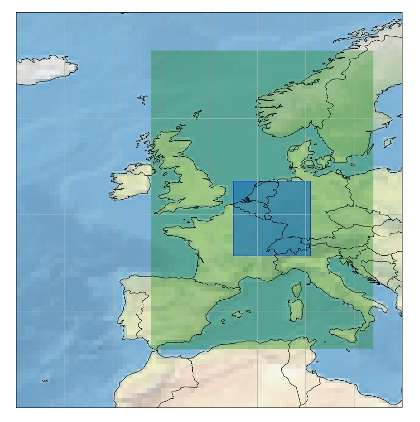
The gridded EUPPBench postprocessing benchmark dataset contains
ECMWF ensemble and deterministic
forecasts over a small domain in Europe, from 45.75° to 53.5° in latitude, and from 2.5° to 10.5° in longitude,
and covers the years 2017-2018.
It also contains the corresponding ERA5 reanalysis for the purpose of
providing observations for the benchmark.
For some dates, it contains also reforecasts that covers 20 years of
past forecasts recomputed with the most recent model version at the given date.
All the forecasts and reforecasts provided are the noon ECMWF runs.
The ensemble forecasts and reforecasts also contain by default the
control run (the 0-th member).
The gridded data resolution is 0.25° x 0.25° which corresponds
roughly to 25 kilometers.
Forecasts and reforecasts are 6-hourly, and include the analysis at 00Z.
By downloading data from this dataset, you agree to the terms and conditions defined at

    https://github.com/Climdyn/climetlab-eumetnet-postprocessing-benchmark/blob/main/DATA_LICENSE

If you do not agree with such terms, do not download the data.
<xarray.Dataset>
Dimensions:     (number: 1, time: 730, step: 5, surface: 1, latitude: 32,
                 longitude: 33)
Coordinates:
  * latitude    (latitude) float64 53.5 53.25 53.0 52.75 ... 46.25 46.0 45.75
  * longitude   (longitude) float64 2.5 2.75 3.0 3.25 ... 9.75 10.0 10.25 10.5
  * number      (number) int64 0
  * step        (step) timedelta64[ns] 1 days 2 days 3 days 4 days 5 days
  * surface     (surface) float64 0.0
  * time        (time) datetime64[ns] 2017-01-01 2017-01-02 ... 2018-12-31
    valid_time  (time, step) datetime64[ns] ...
Data variables:
    capei       (number, time, step, surface, latitude, longitude) float32 ...
    capesi      (number, time, step, surface, latitude, longitude) float32 ...
    fg10i       (number, time, step, surface, latitude, longitude) float32 ...
    mn2ti       (number, time, step, surface, latitude, longitude) float32 ...
    mx2ti       (number, time, step, surface, latitude, longitude) float32 ...
    sfi         (number, time, step, surface, latitude, longitude) float32 ...
    t2i         (number, time, step, surface, latitude, longitude) float32 ...
    tpi         (number, time, step, surface, latitude, longitude) float32 ...
    ws10i       (number, time, step, surface, latitude, longitude) float32 ...
Attributes:
    Conventions:             CF-1.7
    GRIB_centre:             ecmf
    GRIB_centreDescription:  European Centre for Medium-Range Weather Forecasts
    GRIB_edition:            1
    GRIB_subCentre:          0
    history:                 2022-04-26T15:54 GRIB to CDM+CF via cfgrib-0.9.1...
    institution:             European Centre for Medium-Range Weather Forecasts
importeuppbench_datasetscat=euppbench_datasets.open_catalog()# Fetching the ensemble forecastsds_ens=cat.euppbench.training_data.gridded.EUPPBench_ensemble_forecasts_surface.to_dask()# Fetching the deterministic (highres) forecastsds_hr=cat.euppbench.training_data.gridded.EUPPBench_highres_forecasts_surface.to_dask()# Fetching the corresponding observationsds_obs=cat.euppbench.training_data.gridded.EUPPBench_forecasts_observations_surface.to_dask()
By downloading data from this dataset, you agree to the terms and conditions defined at

    https://github.com/Climdyn/climetlab-eumetnet-postprocessing-benchmark/blob/main/DATA_LICENSE

If you do not agree with such terms, do not download the data.
<xarray.Dataset>
Dimensions:              (number: 1, time: 730, step: 21, surface: 1,
                          latitude: 32, longitude: 33, depthBelowLandLayer: 1)
Coordinates:
  * depthBelowLandLayer  (depthBelowLandLayer) float64 0.0
  * latitude             (latitude) float64 53.5 53.25 53.0 ... 46.25 46.0 45.75
  * longitude            (longitude) float64 2.5 2.75 3.0 ... 10.0 10.25 10.5
  * number               (number) int64 0
  * step                 (step) timedelta64[ns] 0 days 00:00:00 ... 5 days 00...
  * surface              (surface) float64 0.0
  * time                 (time) datetime64[ns] 2017-01-01 ... 2018-12-31
    valid_time           (time, step) datetime64[ns] ...
Data variables: (12/14)
    cape                 (number, time, step, surface, latitude, longitude) float32 ...
    cin                  (number, time, step, surface, latitude, longitude) float32 ...
    sd                   (number, time, step, surface, latitude, longitude) float32 ...
    stl1                 (number, time, step, depthBelowLandLayer, latitude, longitude) float32 ...
    swvl1                (number, time, step, depthBelowLandLayer, latitude, longitude) float32 ...
    t2m                  (number, time, step, surface, latitude, longitude) float32 ...
    ...                   ...
    tcwv                 (number, time, step, surface, latitude, longitude) float32 ...
    u10                  (number, time, step, surface, latitude, longitude) float32 ...
    u100                 (number, time, step, surface, latitude, longitude) float32 ...
    v10                  (number, time, step, surface, latitude, longitude) float32 ...
    v100                 (number, time, step, surface, latitude, longitude) float32 ...
    vis                  (number, time, step, surface, latitude, longitude) float32 ...
Attributes:
    Conventions:             CF-1.7
    GRIB_centre:             ecmf
    GRIB_centreDescription:  European Centre for Medium-Range Weather Forecasts
    GRIB_edition:            1
    GRIB_subCentre:          0
    history:                 2022-07-08T12:53 GRIB to CDM+CF via cfgrib-0.9.1...
    institution:             European Centre for Medium-Range Weather Forecasts
PandasIndex(TimedeltaIndex(['0 days 00:00:00', '0 days 06:00:00', '0 days 12:00:00',
                '0 days 18:00:00', '1 days 00:00:00', '1 days 06:00:00',
                '1 days 12:00:00', '1 days 18:00:00', '2 days 00:00:00',
                '2 days 06:00:00', '2 days 12:00:00', '2 days 18:00:00',
                '3 days 00:00:00', '3 days 06:00:00', '3 days 12:00:00',
                '3 days 18:00:00', '4 days 00:00:00', '4 days 06:00:00',
                '4 days 12:00:00', '4 days 18:00:00', '5 days 00:00:00'],
               dtype='timedelta64[ns]', name='step', freq=None))
where the level argument is the pressure level, as a string or an integer. The kind argument
allows to select the deterministic or ensemble forecasts, by setting it
to 'highres' or 'ensemble'.
Alternatively, one can use the Intake catalogue, for example for the 500 hPa level:
importeuppbench_datasetscat=euppbench_datasets.open_catalog()# Fetching the ensemble forecastsds_ens=cat.euppbench.training_data.gridded.EUPPBench_ensemble_forecasts_pressure_500.to_dask()# Fetching the deterministic (highres) forecastsds_hr=cat.euppbench.training_data.gridded.EUPPBench_highres_forecasts_pressure_500.to_dask()# Fetching the corresponding observationsds_obs=cat.euppbench.training_data.gridded.EUPPBench_forecasts_observations_pressure_500.to_dask()
but the other levels can be fetched in the same way, by replacing the 500 in the calls.
By downloading data from this dataset, you agree to the terms and conditions defined at

    https://github.com/Climdyn/climetlab-eumetnet-postprocessing-benchmark/blob/main/DATA_LICENSE

If you do not agree with such terms, do not download the data.
<xarray.Dataset>
Dimensions:        (isobaricInhPa: 1, latitude: 32, longitude: 33, number: 1,
                    step: 21, time: 730)
Coordinates:
  * isobaricInhPa  (isobaricInhPa) float64 500.0
  * latitude       (latitude) float64 53.5 53.25 53.0 52.75 ... 46.25 46.0 45.75
  * longitude      (longitude) float64 2.5 2.75 3.0 3.25 ... 10.0 10.25 10.5
  * number         (number) int64 0
  * step           (step) timedelta64[ns] 0 days 00:00:00 ... 5 days 00:00:00
  * time           (time) datetime64[ns] 2017-01-01 2017-01-02 ... 2018-12-31
    valid_time     (time, step) datetime64[ns] ...
Data variables:
    z              (number, time, step, isobaricInhPa, latitude, longitude) float32 ...
Attributes:
    Conventions:             CF-1.7
    GRIB_centre:             ecmf
    GRIB_centreDescription:  European Centre for Medium-Range Weather Forecasts
    GRIB_edition:            1
    GRIB_subCentre:          0
    history:                 2022-03-28T22:50 GRIB to CDM+CF via cfgrib-0.9.1...
    institution:             European Centre for Medium-Range Weather Forecasts
PandasIndex(TimedeltaIndex(['0 days 00:00:00', '0 days 06:00:00', '0 days 12:00:00',
                '0 days 18:00:00', '1 days 00:00:00', '1 days 06:00:00',
                '1 days 12:00:00', '1 days 18:00:00', '2 days 00:00:00',
                '2 days 06:00:00', '2 days 12:00:00', '2 days 18:00:00',
                '3 days 00:00:00', '3 days 06:00:00', '3 days 12:00:00',
                '3 days 18:00:00', '4 days 00:00:00', '4 days 06:00:00',
                '4 days 12:00:00', '4 days 18:00:00', '5 days 00:00:00'],
               dtype='timedelta64[ns]', name='step', freq=None))
Processed surface variables can be obtained for each forecast date,
both for the ensemble (51 members) and deterministic runs. A
processed variable is either accumulated, averaged or filtered.
All these variables are accumulated or filtered over the last 6 hours
preceding a given forecast timestamp. As a consequence, a `6’ was added to the ECMWF key to denote this.
Usage: The processed surface variables forecasts can be retrieved by calling
importeuppbench_datasetscat=euppbench_datasets.open_catalog()# Fetching the ensemble forecastsds_ens=cat.euppbench.training_data.gridded.EUPPBench_ensemble_forecasts_surface_processed.to_dask()# Fetching the deterministic (highres) forecastsds_hr=cat.euppbench.training_data.gridded.EUPPBench_highres_forecasts_surface_processed.to_dask()# Fetching the corresponding observationsds_obs=cat.euppbench.training_data.gridded.EUPPBench_forecasts_observations_surface_processed.to_dask()
By downloading data from this dataset, you agree to the terms and conditions defined at

    https://github.com/Climdyn/climetlab-eumetnet-postprocessing-benchmark/blob/main/DATA_LICENSE

If you do not agree with such terms, do not download the data.
<xarray.Dataset>
Dimensions:     (number: 1, time: 730, step: 20, surface: 1, latitude: 32,
                 longitude: 33)
Coordinates:
  * latitude    (latitude) float64 53.5 53.25 53.0 52.75 ... 46.25 46.0 45.75
  * longitude   (longitude) float64 2.5 2.75 3.0 3.25 ... 9.75 10.0 10.25 10.5
  * number      (number) int64 0
  * step        (step) timedelta64[ns] 0 days 06:00:00 ... 5 days 00:00:00
  * surface     (surface) float64 0.0
  * time        (time) datetime64[ns] 2017-01-01 2017-01-02 ... 2018-12-31
    valid_time  (time, step) datetime64[ns] ...
Data variables:
    cp6         (number, time, step, surface, latitude, longitude) float32 ...
    mn2t6       (number, time, step, surface, latitude, longitude) float32 ...
    mx2t6       (number, time, step, surface, latitude, longitude) float32 ...
    p10fg6      (number, time, step, surface, latitude, longitude) float32 ...
    slhf6       (number, time, step, surface, latitude, longitude) float32 ...
    sshf6       (number, time, step, surface, latitude, longitude) float32 ...
    ssr6        (number, time, step, surface, latitude, longitude) float32 ...
    ssrd6       (number, time, step, surface, latitude, longitude) float32 ...
    str6        (number, time, step, surface, latitude, longitude) float32 ...
    strd6       (number, time, step, surface, latitude, longitude) float32 ...
    tp6         (number, time, step, surface, latitude, longitude) float32 ...
Attributes:
    Conventions:             CF-1.7
    GRIB_centre:             ecmf
    GRIB_centreDescription:  European Centre for Medium-Range Weather Forecasts
    GRIB_edition:            1
    GRIB_subCentre:          0
    history:                 2022-03-25T11:54 GRIB to CDM+CF via cfgrib-0.9.1...
    institution:             European Centre for Medium-Range Weather Forecasts
PandasIndex(TimedeltaIndex(['0 days 06:00:00', '0 days 12:00:00', '0 days 18:00:00',
                '1 days 00:00:00', '1 days 06:00:00', '1 days 12:00:00',
                '1 days 18:00:00', '2 days 00:00:00', '2 days 06:00:00',
                '2 days 12:00:00', '2 days 18:00:00', '3 days 00:00:00',
                '3 days 06:00:00', '3 days 12:00:00', '3 days 18:00:00',
                '4 days 00:00:00', '4 days 06:00:00', '4 days 12:00:00',
                '4 days 18:00:00', '5 days 00:00:00'],
               dtype='timedelta64[ns]', name='step', freq=None))
The surface variables for the ensemble reforecasts (11 members) can be
obtained for each reforecast date. All the variables described at in the section 1.2 - Surface variable forecasts
above are available.
Note
The ECMWF reforecasts are only available on dates corresponding to Mondays and
Thursdays.
Usage: The surface variables reforecasts can be retrieved by calling
importeuppbench_datasetscat=euppbench_datasets.open_catalog()# Fetching the ensemble reforecastsds_ens=cat.euppbench.training_data.gridded.EUPPBench_ensemble_reforecasts_surface.to_dask()# Fetching the corresponding observationsds_obs=cat.euppbench.training_data.gridded.EUPPBench_reforecasts_observations_surface.to_dask()
By downloading data from this dataset, you agree to the terms and conditions defined at

    https://github.com/Climdyn/climetlab-eumetnet-postprocessing-benchmark/blob/main/DATA_LICENSE

If you do not agree with such terms, do not download the data.
PandasIndex(TimedeltaIndex(['0 days 00:00:00', '0 days 06:00:00', '0 days 12:00:00',
                '0 days 18:00:00', '1 days 00:00:00', '1 days 06:00:00',
                '1 days 12:00:00', '1 days 18:00:00', '2 days 00:00:00',
                '2 days 06:00:00', '2 days 12:00:00', '2 days 18:00:00',
                '3 days 00:00:00', '3 days 06:00:00', '3 days 12:00:00',
                '3 days 18:00:00', '4 days 00:00:00', '4 days 06:00:00',
                '4 days 12:00:00', '4 days 18:00:00', '5 days 00:00:00'],
               dtype='timedelta64[ns]', name='step', freq=None))
The variables on pressure level for the ensemble reforecasts (11
members) can be obtained for each reforecast date. All the variables
described in the section 1.3 - Pressure level variable forecasts above are available.
Note
The ECMWF reforecasts are only available on dates corresponding to Mondays and
Thursdays.
Usage: The pressure level variables reforecasts can be retrieved by
calling
The level argument is the pressure level, as a string or an integer.
Alternatively, one can use the Intake catalogue, for example for the 500 hPa level:
importeuppbench_datasetscat=euppbench_datasets.open_catalog()# Fetching the ensemble reforecastsds_ens=cat.euppbench.training_data.gridded.EUPPBench_ensemble_reforecasts_pressure_500.to_dask()# Fetching the corresponding observationsds_obs=cat.euppbench.training_data.gridded.EUPPBench_reforecasts_observations_pressure_500.to_dask()
but the other levels can be fetched in the same way, by replacing the 500 in the calls.
By downloading data from this dataset, you agree to the terms and conditions defined at

    https://github.com/Climdyn/climetlab-eumetnet-postprocessing-benchmark/blob/main/DATA_LICENSE

If you do not agree with such terms, do not download the data.
<xarray.Dataset>
Dimensions:        (isobaricInhPa: 1, latitude: 32, longitude: 33, number: 11,
                    step: 21, time: 209, year: 20)
Coordinates:
  * isobaricInhPa  (isobaricInhPa) float64 500.0
  * latitude       (latitude) float64 53.5 53.25 53.0 52.75 ... 46.25 46.0 45.75
  * longitude      (longitude) float64 2.5 2.75 3.0 3.25 ... 10.0 10.25 10.5
  * number         (number) int64 0 1 2 3 4 5 6 7 8 9 10
  * step           (step) timedelta64[ns] 0 days 00:00:00 ... 5 days 00:00:00
  * time           (time) datetime64[ns] 2017-01-02 2017-01-05 ... 2018-12-31
    valid_time     (time, year, step) datetime64[ns] ...
  * year           (year) int64 1 2 3 4 5 6 7 8 9 ... 12 13 14 15 16 17 18 19 20
Data variables:
    z              (time, number, year, step, isobaricInhPa, latitude, longitude) float32 ...
Attributes:
    Conventions:             CF-1.7
    GRIB_centre:             ecmf
    GRIB_centreDescription:  European Centre for Medium-Range Weather Forecasts
    GRIB_edition:            1
    GRIB_subCentre:          0
    history:                 2022-04-15T20:40 GRIB to CDM+CF via cfgrib-0.9.1...
    institution:             European Centre for Medium-Range Weather Forecasts
PandasIndex(TimedeltaIndex(['0 days 00:00:00', '0 days 06:00:00', '0 days 12:00:00',
                '0 days 18:00:00', '1 days 00:00:00', '1 days 06:00:00',
                '1 days 12:00:00', '1 days 18:00:00', '2 days 00:00:00',
                '2 days 06:00:00', '2 days 12:00:00', '2 days 18:00:00',
                '3 days 00:00:00', '3 days 06:00:00', '3 days 12:00:00',
                '3 days 18:00:00', '4 days 00:00:00', '4 days 06:00:00',
                '4 days 12:00:00', '4 days 18:00:00', '5 days 00:00:00'],
               dtype='timedelta64[ns]', name='step', freq=None))
importeuppbench_datasetscat=euppbench_datasets.open_catalog()# Fetching the ensemble reforecastsds_ens=cat.euppbench.training_data.gridded.EUPPBench_ensemble_reforecasts_surface_processed.to_dask()# Fetching the corresponding observationsds_obs=cat.euppbench.training_data.gridded.EUPPBench_reforecasts_observations_surface_processed.to_dask()
By downloading data from this dataset, you agree to the terms and conditions defined at

    https://github.com/Climdyn/climetlab-eumetnet-postprocessing-benchmark/blob/main/DATA_LICENSE

If you do not agree with such terms, do not download the data.
PandasIndex(TimedeltaIndex(['0 days 06:00:00', '0 days 12:00:00', '0 days 18:00:00',
                '1 days 00:00:00', '1 days 06:00:00', '1 days 12:00:00',
                '1 days 18:00:00', '2 days 00:00:00', '2 days 06:00:00',
                '2 days 12:00:00', '2 days 18:00:00', '3 days 00:00:00',
                '3 days 06:00:00', '3 days 12:00:00', '3 days 18:00:00',
                '4 days 00:00:00', '4 days 06:00:00', '4 days 12:00:00',
                '4 days 18:00:00', '5 days 00:00:00'],
               dtype='timedelta64[ns]', name='step', freq=None))
Various static fields associated to the forecast grid can be obtained,
with the purpose of serving as predictors for the postprocessing.
Note
For consistency with the rest of the dataset, we use the
ECMWF parameters name, terminology and units here. However, please
note that - except for the Surface Geopotential - the fields provided are from other non-ECMWF data sources
evaluated at grid points. Currently, the main data source being used
is the Copernicus Land Monitoring
Service.
Extracted from the CORINE 2018 dataset.
Values and associated land type differ from the ECMWF one.
Please look at the “legend” entry in the metadata for more details.
importeuppbench_datasetscat=euppbench_datasets.open_catalog()# Fetching the land usage fieldds=cat.euppbench.training_data.gridded.EUPPBench_land_use.to_dask()
The other static field are also available in the same way.
By downloading data from this dataset, you agree to the terms and conditions defined at

    https://github.com/Climdyn/climetlab-eumetnet-postprocessing-benchmark/blob/main/DATA_LICENSE

If you do not agree with such terms, do not download the data.
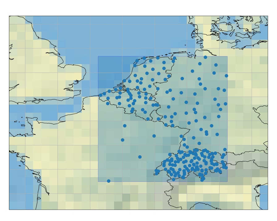
The stations EUPPBench postprocessing benchmark dataset contains
ECMWF ensemble and deterministic
forecasts at the grid point closest to the station locations, and covers the years 2017-2018.
It also contains the corresponding stations observations.
For some dates, it contains also reforecasts that covers 20 years of
past forecasts recomputed with the most recent model version at the given date.
All the forecasts and reforecasts provided are the noon ECMWF runs.
The ensemble forecasts and reforecasts also contain by default the
control run (the 0-th member).
5 countries are presently available: Belgium, Austria, France, Germany, The Netherlands.
By downloading data from this dataset, you agree to the terms and conditions defined at

    https://github.com/Climdyn/climetlab-eumetnet-postprocessing-benchmark/blob/main/DATA_LICENSE

If you do not agree with such terms, do not download the data.
<xarray.Dataset>
Dimensions:             (station_id: 4, number: 1, time: 730, step: 5,
                         surface: 1)
Coordinates: (12/15)
    model_altitude      (station_id) float32 ...
    model_land_usage    (station_id) int8 ...
    model_latitude      (station_id) float64 ...
    model_longitude     (station_id) float64 ...
    model_orography     (station_id) float64 ...
  * number              (number) int64 0
    ...                  ...
    station_latitude    (station_id) float64 ...
    station_longitude   (station_id) float64 ...
    station_name        (station_id) <U20 ...
  * step                (step) timedelta64[ns] 1 days 2 days ... 4 days 5 days
  * surface             (surface) float64 0.0
  * time                (time) datetime64[ns] 2017-01-01 ... 2018-12-31
Data variables:
    capei               (station_id, number, time, step, surface) float32 ...
    capesi              (station_id, number, time, step, surface) float32 ...
    fg10i               (station_id, number, time, step, surface) float32 ...
    mn2ti               (station_id, number, time, step, surface) float32 ...
    mx2ti               (station_id, number, time, step, surface) float32 ...
    sfi                 (station_id, number, time, step, surface) float32 ...
    t2i                 (station_id, number, time, step, surface) float32 ...
    tpi                 (station_id, number, time, step, surface) float32 ...
    valid_time          (time, step) datetime64[ns] ...
    ws10i               (station_id, number, time, step, surface) float32 ...
Attributes:
    Conventions:             CF-1.7
    GRIB_centre:             ecmf
    GRIB_centreDescription:  European Centre for Medium-Range Weather Forecasts
    GRIB_edition:            1
    GRIB_subCentre:          0
    history:                 2022-04-26T15:54 GRIB to CDM+CF via cfgrib-0.9.1...
    institution:             European Centre for Medium-Range Weather Forecasts
    land usage history:      Retrieved from https://land.copernicus.eu/pan-eu...
    land usage legend:       {1: {'label': '111 - Continuous urban fabric', '...
    land usage source:       European Union, Copernicus Land Monitoring Servi...
    model altitude history:  Retrieved from https://land.copernicus.eu/imager...
    model altitude source:   European Union, Copernicus Land Monitoring Servi...
European Centre for Medium-Range Weather Forecasts
GRIB_edition :
1
GRIB_subCentre :
0
history :
2022-04-26T15:54 GRIB to CDM+CF via cfgrib-0.9.10.1/ecCodes-2.24.2 with {"source": "N/A", "filter_by_keys": {}, "encode_cf": ["parameter", "time", "geography", "vertical"]}
Grid point values extracted with xarray by Jonathan Demaeyer, August 2022
institution :
European Centre for Medium-Range Weather Forecasts
land usage history :
Retrieved from https://land.copernicus.eu/pan-european/corine-land-cover, July 2022
where the kind argument allows to select the
deterministic or ensemble forecasts, by setting it to 'highres' or
'ensemble'.
The country argument must be chosen amongst the list [belgium, austria, france, germany, netherlands].
importeuppbench_datasetscat=euppbench_datasets.open_catalog()# Fetching the ensemble forecastsds_ens=cat.euppbench.training_data.stations.austria.EUPPBench_ensemble_forecasts_surface.to_dask()# Fetching the deterministic (highres) forecastsds_hr=cat.euppbench.training_data.stations.austria.EUPPBench_highres_forecasts_surface.to_dask()# Fetching the corresponding observationsds_obs=cat.euppbench.training_data.stations.austria.EUPPBench_forecasts_observations_surface.to_dask()
where austria can be replaced by another country in the list [belgium, austria, france, germany, netherlands].
By downloading data from this dataset, you agree to the terms and conditions defined at

    https://github.com/Climdyn/climetlab-eumetnet-postprocessing-benchmark/blob/main/DATA_LICENSE

If you do not agree with such terms, do not download the data.
<xarray.Dataset>
Dimensions:              (station_id: 4, number: 1, time: 730, step: 21,
                          surface: 1, depthBelowLandLayer: 1)
Coordinates: (12/16)
  * depthBelowLandLayer  (depthBelowLandLayer) float64 0.0
    model_altitude       (station_id) float32 ...
    model_land_usage     (station_id) int8 ...
    model_latitude       (station_id) float64 ...
    model_longitude      (station_id) float64 ...
    model_orography      (station_id) float64 ...
    ...                   ...
    station_latitude     (station_id) float64 ...
    station_longitude    (station_id) float64 ...
    station_name         (station_id) <U20 ...
  * step                 (step) timedelta64[ns] 0 days 00:00:00 ... 5 days 00...
  * surface              (surface) float64 0.0
  * time                 (time) datetime64[ns] 2017-01-01 ... 2018-12-31
Data variables: (12/15)
    cape                 (station_id, number, time, step, surface) float32 ...
    cin                  (station_id, number, time, step, surface) float32 ...
    sd                   (station_id, number, time, step, surface) float32 ...
    stl1                 (station_id, number, time, step, depthBelowLandLayer) float32 ...
    swvl1                (station_id, number, time, step, depthBelowLandLayer) float32 ...
    t2m                  (station_id, number, time, step, surface) float32 ...
    ...                   ...
    u10                  (station_id, number, time, step, surface) float32 ...
    u100                 (station_id, number, time, step, surface) float32 ...
    v10                  (station_id, number, time, step, surface) float32 ...
    v100                 (station_id, number, time, step, surface) float32 ...
    valid_time           (time, step) datetime64[ns] ...
    vis                  (station_id, number, time, step, surface) float32 ...
Attributes:
    Conventions:             CF-1.7
    GRIB_centre:             ecmf
    GRIB_centreDescription:  European Centre for Medium-Range Weather Forecasts
    GRIB_edition:            1
    GRIB_subCentre:          0
    history:                 2022-07-08T12:53 GRIB to CDM+CF via cfgrib-0.9.1...
    institution:             European Centre for Medium-Range Weather Forecasts
    land usage history:      Retrieved from https://land.copernicus.eu/pan-eu...
    land usage legend:       {1: {'label': '111 - Continuous urban fabric', '...
    land usage source:       European Union, Copernicus Land Monitoring Servi...
    model altitude history:  Retrieved from https://land.copernicus.eu/imager...
    model altitude source:   European Union, Copernicus Land Monitoring Servi...
PandasIndex(TimedeltaIndex(['0 days 00:00:00', '0 days 06:00:00', '0 days 12:00:00',
                '0 days 18:00:00', '1 days 00:00:00', '1 days 06:00:00',
                '1 days 12:00:00', '1 days 18:00:00', '2 days 00:00:00',
                '2 days 06:00:00', '2 days 12:00:00', '2 days 18:00:00',
                '3 days 00:00:00', '3 days 06:00:00', '3 days 12:00:00',
                '3 days 18:00:00', '4 days 00:00:00', '4 days 06:00:00',
                '4 days 12:00:00', '4 days 18:00:00', '5 days 00:00:00'],
               dtype='timedelta64[ns]', name='step', freq=None))
European Centre for Medium-Range Weather Forecasts
GRIB_edition :
1
GRIB_subCentre :
0
history :
2022-07-08T12:53 GRIB to CDM+CF via cfgrib-0.9.10.1/ecCodes-2.24.2 with {"source": "N/A", "filter_by_keys": {}, "encode_cf": ["parameter", "time", "geography", "vertical"]}
Grid point values extracted with xarray by Jonathan Demaeyer, August 2022
institution :
European Centre for Medium-Range Weather Forecasts
land usage history :
Retrieved from https://land.copernicus.eu/pan-european/corine-land-cover, July 2022
where the level argument is the pressure level, as a string or an integer. The kind argument
allows to select the deterministic or ensemble forecasts, by setting it
to 'highres' or 'ensemble'.
The country argument must be chosen amongst the list [belgium, austria, france, germany, netherlands].
Alternatively, one can use the Intake catalogue, for example for the 500 hPa level:
importeuppbench_datasetscat=euppbench_datasets.open_catalog()# Fetching the ensemble forecastsds_ens=cat.euppbench.training_data.stations.austria.EUPPBench_ensemble_forecasts_pressure_500.to_dask()# Fetching the corresponding observationsds_obs=cat.euppbench.training_data.stations.austria.EUPPBench_forecasts_observations_pressure_500.to_dask()
but the other levels can be fetched in the same way, by replacing the 500 in the calls.
The country can also be changed, by replacing austria by another country in the list [belgium, austria, france, germany, netherlands].
By downloading data from this dataset, you agree to the terms and conditions defined at

    https://github.com/Climdyn/climetlab-eumetnet-postprocessing-benchmark/blob/main/DATA_LICENSE

If you do not agree with such terms, do not download the data.
<xarray.Dataset>
Dimensions:             (isobaricInhPa: 1, station_id: 4, number: 1, step: 21,
                         time: 730)
Coordinates: (12/15)
  * isobaricInhPa       (isobaricInhPa) float64 500.0
    model_altitude      (station_id) float32 ...
    model_land_usage    (station_id) int8 ...
    model_latitude      (station_id) float64 ...
    model_longitude     (station_id) float64 ...
    model_orography     (station_id) float64 ...
    ...                  ...
    station_land_usage  (station_id) int8 ...
    station_latitude    (station_id) float64 ...
    station_longitude   (station_id) float64 ...
    station_name        (station_id) <U20 ...
  * step                (step) timedelta64[ns] 0 days 00:00:00 ... 5 days 00:...
  * time                (time) datetime64[ns] 2017-01-01 ... 2018-12-31
Data variables:
    valid_time          (time, step) datetime64[ns] ...
    z                   (station_id, number, time, step, isobaricInhPa) float32 ...
Attributes:
    Conventions:             CF-1.7
    GRIB_centre:             ecmf
    GRIB_centreDescription:  European Centre for Medium-Range Weather Forecasts
    GRIB_edition:            1
    GRIB_subCentre:          0
    history:                 2022-03-28T22:50 GRIB to CDM+CF via cfgrib-0.9.1...
    institution:             European Centre for Medium-Range Weather Forecasts
    land usage history:      Retrieved from https://land.copernicus.eu/pan-eu...
    land usage legend:       {1: {'label': '111 - Continuous urban fabric', '...
    land usage source:       European Union, Copernicus Land Monitoring Servi...
    model altitude history:  Retrieved from https://land.copernicus.eu/imager...
    model altitude source:   European Union, Copernicus Land Monitoring Servi...
PandasIndex(TimedeltaIndex(['0 days 00:00:00', '0 days 06:00:00', '0 days 12:00:00',
                '0 days 18:00:00', '1 days 00:00:00', '1 days 06:00:00',
                '1 days 12:00:00', '1 days 18:00:00', '2 days 00:00:00',
                '2 days 06:00:00', '2 days 12:00:00', '2 days 18:00:00',
                '3 days 00:00:00', '3 days 06:00:00', '3 days 12:00:00',
                '3 days 18:00:00', '4 days 00:00:00', '4 days 06:00:00',
                '4 days 12:00:00', '4 days 18:00:00', '5 days 00:00:00'],
               dtype='timedelta64[ns]', name='step', freq=None))
European Centre for Medium-Range Weather Forecasts
GRIB_edition :
1
GRIB_subCentre :
0
history :
2022-03-28T22:50 GRIB to CDM+CF via cfgrib-0.9.10.1/ecCodes-2.24.2 with {"source": "N/A", "filter_by_keys": {}, "encode_cf": ["parameter", "time", "geography", "vertical"]}
Grid point values extracted with xarray by Jonathan Demaeyer, August 2022
institution :
European Centre for Medium-Range Weather Forecasts
land usage history :
Retrieved from https://land.copernicus.eu/pan-european/corine-land-cover, July 2022
Processed surface variables can be obtained for each forecast date,
both for the ensemble (51 members) and deterministic runs. A
processed variable is either accumulated, averaged or filtered.
where the kind argument allows to select the deterministic or ensemble forecasts, by setting it to 'highres' or
'ensemble'.
The country argument must be chosen amongst the list [belgium, austria, france, germany, netherlands].
importeuppbench_datasetscat=euppbench_datasets.open_catalog()# Fetching the ensemble forecastsds_ens=cat.euppbench.training_data.stations.austria.EUPPBench_ensemble_forecasts_surface_processed.to_dask()# Fetching the deterministic (highres) forecastsds_hr=cat.euppbench.training_data.stations.austria.EUPPBench_highres_forecasts_surface_processed.to_dask()# Fetching the corresponding observationsds_obs=cat.euppbench.training_data.stations.austria.EUPPBench_forecasts_observations_surface_processed.to_dask()
where austria can be replaced by another country in the list [belgium, austria, france, germany, netherlands].
By downloading data from this dataset, you agree to the terms and conditions defined at

    https://github.com/Climdyn/climetlab-eumetnet-postprocessing-benchmark/blob/main/DATA_LICENSE

If you do not agree with such terms, do not download the data.
<xarray.Dataset>
Dimensions:             (station_id: 4, number: 1, time: 730, step: 20,
                         surface: 1)
Coordinates: (12/16)
    model_altitude      (station_id) float32 ...
    model_land_usage    (station_id) int8 ...
    model_latitude      (station_id) float64 ...
    model_longitude     (station_id) float64 ...
    model_orography     (station_id) float64 ...
  * number              (number) int64 0
    ...                  ...
    station_longitude   (station_id) float64 ...
    station_name        (station_id) <U20 ...
  * step                (step) timedelta64[ns] 0 days 06:00:00 ... 5 days 00:...
  * surface             (surface) float64 0.0
  * time                (time) datetime64[ns] 2017-01-01 ... 2018-12-31
    valid_time          (time, step) datetime64[ns] ...
Data variables:
    cp6                 (station_id, number, time, step, surface) float32 ...
    mn2t6               (station_id, number, time, step, surface) float32 ...
    mx2t6               (station_id, number, time, step, surface) float32 ...
    p10fg6              (station_id, number, time, step, surface) float32 ...
    slhf6               (station_id, number, time, step, surface) float32 ...
    sshf6               (station_id, number, time, step, surface) float32 ...
    ssr6                (station_id, number, time, step, surface) float32 ...
    ssrd6               (station_id, number, time, step, surface) float32 ...
    str6                (station_id, number, time, step, surface) float32 ...
    strd6               (station_id, number, time, step, surface) float32 ...
    tp6                 (station_id, number, time, step, surface) float32 ...
Attributes:
    Conventions:             CF-1.7
    GRIB_centre:             ecmf
    GRIB_centreDescription:  European Centre for Medium-Range Weather Forecasts
    GRIB_edition:            1
    GRIB_subCentre:          0
    history:                 2022-03-25T11:54 GRIB to CDM+CF via cfgrib-0.9.1...
    institution:             European Centre for Medium-Range Weather Forecasts
    land usage history:      Retrieved from https://land.copernicus.eu/pan-eu...
    land usage legend:       {1: {'label': '111 - Continuous urban fabric', '...
    land usage source:       European Union, Copernicus Land Monitoring Servi...
    model altitude history:  Retrieved from https://land.copernicus.eu/imager...
    model altitude source:   European Union, Copernicus Land Monitoring Servi...
PandasIndex(TimedeltaIndex(['0 days 06:00:00', '0 days 12:00:00', '0 days 18:00:00',
                '1 days 00:00:00', '1 days 06:00:00', '1 days 12:00:00',
                '1 days 18:00:00', '2 days 00:00:00', '2 days 06:00:00',
                '2 days 12:00:00', '2 days 18:00:00', '3 days 00:00:00',
                '3 days 06:00:00', '3 days 12:00:00', '3 days 18:00:00',
                '4 days 00:00:00', '4 days 06:00:00', '4 days 12:00:00',
                '4 days 18:00:00', '5 days 00:00:00'],
               dtype='timedelta64[ns]', name='step', freq=None))
European Centre for Medium-Range Weather Forecasts
GRIB_edition :
1
GRIB_subCentre :
0
history :
2022-03-25T11:54 GRIB to CDM+CF via cfgrib-0.9.10.1/ecCodes-2.24.2 with {"source": "N/A", "filter_by_keys": {}, "encode_cf": ["parameter", "time", "geography", "vertical"]}
Grid point values extracted with xarray by Jonathan Demaeyer, August 2022
institution :
European Centre for Medium-Range Weather Forecasts
land usage history :
Retrieved from https://land.copernicus.eu/pan-european/corine-land-cover, July 2022
The surface variables for the ensemble reforecasts (11 members) can be
obtained for each reforecast date. All the variables described at in the section 1.2 - Surface variable forecasts
above are available.
Note
The ECMWF reforecasts are only available on dates corresponding to Mondays and
Thursdays.
Note
Only the variables t2m, vis and tcc have presently station observations.
Usage: The surface variables reforecasts can be retrieved by calling
importeuppbench_datasetscat=euppbench_datasets.open_catalog()# Fetching the ensemble reforecastsds_ens=cat.euppbench.training_data.stations.austria.EUPPBench_ensemble_reforecasts_surface.to_dask()# Fetching the corresponding observationsds_obs=cat.euppbench.training_data.stations.austria.EUPPBench_reforecasts_observations_surface.to_dask()
where austria can be replaced by another country in the list [belgium, austria, france, germany, netherlands].
By downloading data from this dataset, you agree to the terms and conditions defined at

    https://github.com/Climdyn/climetlab-eumetnet-postprocessing-benchmark/blob/main/DATA_LICENSE

If you do not agree with such terms, do not download the data.
<xarray.Dataset>
Dimensions:              (station_id: 4, time: 209, number: 11, year: 20,
                          step: 21, surface: 1, depthBelowLandLayer: 1)
Coordinates: (12/17)
  * depthBelowLandLayer  (depthBelowLandLayer) float64 0.0
    model_altitude       (station_id) float32 ...
    model_land_usage     (station_id) int8 ...
    model_latitude       (station_id) float64 ...
    model_longitude      (station_id) float64 ...
    model_orography      (station_id) float64 ...
    ...                   ...
    station_longitude    (station_id) float64 ...
    station_name         (station_id) <U20 ...
  * step                 (step) timedelta64[ns] 0 days 00:00:00 ... 5 days 00...
  * surface              (surface) float64 0.0
  * time                 (time) datetime64[ns] 2017-01-02 ... 2018-12-31
  * year                 (year) int64 1 2 3 4 5 6 7 8 ... 14 15 16 17 18 19 20
Data variables: (12/15)
    cape                 (station_id, time, number, year, step, surface) float32 ...
    cin                  (station_id, time, number, year, step, surface) float32 ...
    sd                   (station_id, time, number, year, step, surface) float32 ...
    stl1                 (station_id, time, number, year, step, depthBelowLandLayer) float32 ...
    swvl1                (station_id, time, number, year, step, depthBelowLandLayer) float32 ...
    t2m                  (station_id, time, number, year, step, surface) float32 ...
    ...                   ...
    u10                  (station_id, time, number, year, step, surface) float32 ...
    u100                 (station_id, time, number, year, step, surface) float32 ...
    v10                  (station_id, time, number, year, step, surface) float32 ...
    v100                 (station_id, time, number, year, step, surface) float32 ...
    valid_time           (time, year, step) datetime64[ns] ...
    vis                  (station_id, time, number, year, step, surface) float32 ...
Attributes:
    Conventions:             CF-1.7
    GRIB_centre:             ecmf
    GRIB_centreDescription:  European Centre for Medium-Range Weather Forecasts
    GRIB_edition:            1
    GRIB_subCentre:          0
    history:                 2022-07-08T08:03 GRIB to CDM+CF via cfgrib-0.9.1...
    institution:             European Centre for Medium-Range Weather Forecasts
    land usage history:      Retrieved from https://land.copernicus.eu/pan-eu...
    land usage legend:       {1: {'label': '111 - Continuous urban fabric', '...
    land usage source:       European Union, Copernicus Land Monitoring Servi...
    model altitude history:  Retrieved from https://land.copernicus.eu/imager...
    model altitude source:   European Union, Copernicus Land Monitoring Servi...
PandasIndex(TimedeltaIndex(['0 days 00:00:00', '0 days 06:00:00', '0 days 12:00:00',
                '0 days 18:00:00', '1 days 00:00:00', '1 days 06:00:00',
                '1 days 12:00:00', '1 days 18:00:00', '2 days 00:00:00',
                '2 days 06:00:00', '2 days 12:00:00', '2 days 18:00:00',
                '3 days 00:00:00', '3 days 06:00:00', '3 days 12:00:00',
                '3 days 18:00:00', '4 days 00:00:00', '4 days 06:00:00',
                '4 days 12:00:00', '4 days 18:00:00', '5 days 00:00:00'],
               dtype='timedelta64[ns]', name='step', freq=None))
European Centre for Medium-Range Weather Forecasts
GRIB_edition :
1
GRIB_subCentre :
0
history :
2022-07-08T08:03 GRIB to CDM+CF via cfgrib-0.9.10.1/ecCodes-2.24.2 with {"source": "N/A", "filter_by_keys": {}, "encode_cf": ["parameter", "time", "geography", "vertical"]}
Grid point values extracted with xarray by Jonathan Demaeyer, August 2022
institution :
European Centre for Medium-Range Weather Forecasts
land usage history :
Retrieved from https://land.copernicus.eu/pan-european/corine-land-cover, July 2022
The variables on pressure level for the ensemble reforecasts (11
members) can be obtained for each reforecast date. All the variables
described in the section 1.3 - Pressure level variable forecasts above are available.
Note
The ECMWF reforecasts are only available on dates corresponding to Mondays and
Thursdays.
Note
For obvious reasons, station observations are not available on pressure levels.
Usage: The pressure level variables reforecasts can be retrieved by
calling
The level argument is the pressure level, as a string or an integer.
The country argument must be chosen amongst the list [belgium, austria, france, germany, netherlands].
Alternatively, one can use the Intake catalogue, for example for the 500 hPa level:
importeuppbench_datasetscat=euppbench_datasets.open_catalog()# Fetching the ensemble reforecastsds_ens=cat.euppbench.training_data.stations.austria.EUPPBench_ensemble_reforecasts_pressure_500.to_dask()
but the other levels can be fetched in the same way, by replacing the 500 in the calls.
The country can also be changed, by replacing austria by another country in the list [belgium, austria, france, germany, netherlands].
By downloading data from this dataset, you agree to the terms and conditions defined at

    https://github.com/Climdyn/climetlab-eumetnet-postprocessing-benchmark/blob/main/DATA_LICENSE

If you do not agree with such terms, do not download the data.
<xarray.Dataset>
Dimensions:             (isobaricInhPa: 1, station_id: 4, number: 11, step: 21,
                         time: 209, year: 20)
Coordinates: (12/16)
  * isobaricInhPa       (isobaricInhPa) float64 500.0
    model_altitude      (station_id) float32 ...
    model_land_usage    (station_id) int8 ...
    model_latitude      (station_id) float64 ...
    model_longitude     (station_id) float64 ...
    model_orography     (station_id) float64 ...
    ...                  ...
    station_latitude    (station_id) float64 ...
    station_longitude   (station_id) float64 ...
    station_name        (station_id) <U20 ...
  * step                (step) timedelta64[ns] 0 days 00:00:00 ... 5 days 00:...
  * time                (time) datetime64[ns] 2017-01-02 ... 2018-12-31
  * year                (year) int64 1 2 3 4 5 6 7 8 ... 13 14 15 16 17 18 19 20
Data variables:
    valid_time          (time, year, step) datetime64[ns] ...
    z                   (station_id, time, number, year, step, isobaricInhPa) float32 ...
Attributes:
    Conventions:             CF-1.7
    GRIB_centre:             ecmf
    GRIB_centreDescription:  European Centre for Medium-Range Weather Forecasts
    GRIB_edition:            1
    GRIB_subCentre:          0
    history:                 2022-04-15T20:40 GRIB to CDM+CF via cfgrib-0.9.1...
    institution:             European Centre for Medium-Range Weather Forecasts
    land usage history:      Retrieved from https://land.copernicus.eu/pan-eu...
    land usage legend:       {1: {'label': '111 - Continuous urban fabric', '...
    land usage source:       European Union, Copernicus Land Monitoring Servi...
    model altitude history:  Retrieved from https://land.copernicus.eu/imager...
    model altitude source:   European Union, Copernicus Land Monitoring Servi...
PandasIndex(TimedeltaIndex(['0 days 00:00:00', '0 days 06:00:00', '0 days 12:00:00',
                '0 days 18:00:00', '1 days 00:00:00', '1 days 06:00:00',
                '1 days 12:00:00', '1 days 18:00:00', '2 days 00:00:00',
                '2 days 06:00:00', '2 days 12:00:00', '2 days 18:00:00',
                '3 days 00:00:00', '3 days 06:00:00', '3 days 12:00:00',
                '3 days 18:00:00', '4 days 00:00:00', '4 days 06:00:00',
                '4 days 12:00:00', '4 days 18:00:00', '5 days 00:00:00'],
               dtype='timedelta64[ns]', name='step', freq=None))
European Centre for Medium-Range Weather Forecasts
GRIB_edition :
1
GRIB_subCentre :
0
history :
2022-04-15T20:40 GRIB to CDM+CF via cfgrib-0.9.10.1/ecCodes-2.24.2 with {"source": "N/A", "filter_by_keys": {}, "encode_cf": ["parameter", "time", "geography", "vertical"]}
Grid point values extracted with xarray by Jonathan Demaeyer, August 2022
institution :
European Centre for Medium-Range Weather Forecasts
land usage history :
Retrieved from https://land.copernicus.eu/pan-european/corine-land-cover, July 2022
importeuppbench_datasetscat=euppbench_datasets.open_catalog()# Fetching the ensemble reforecastsds_ens=cat.euppbench.training_data.stations.austria.EUPPBench_ensemble_reforecasts_surface_processed.to_dask()# Fetching the corresponding observationsds_obs=cat.euppbench.training_data.stations.austria.EUPPBench_reforecasts_observations_surface_processed.to_dask()
where austria can be replaced by another country in the list [belgium, austria, france, germany, netherlands].
By downloading data from this dataset, you agree to the terms and conditions defined at

    https://github.com/Climdyn/climetlab-eumetnet-postprocessing-benchmark/blob/main/DATA_LICENSE

If you do not agree with such terms, do not download the data.
<xarray.Dataset>
Dimensions:             (station_id: 4, time: 209, number: 11, year: 20,
                         step: 20, surface: 1)
Coordinates: (12/17)
    model_altitude      (station_id) float32 ...
    model_land_usage    (station_id) int8 ...
    model_latitude      (station_id) float64 ...
    model_longitude     (station_id) float64 ...
    model_orography     (station_id) float64 ...
  * number              (number) int64 0 1 2 3 4 5 6 7 8 9 10
    ...                  ...
    station_name        (station_id) <U20 ...
  * step                (step) timedelta64[ns] 0 days 06:00:00 ... 5 days 00:...
  * surface             (surface) float64 0.0
  * time                (time) datetime64[ns] 2017-01-02 ... 2018-12-31
    valid_time          (time, year, step) datetime64[ns] ...
  * year                (year) int64 1 2 3 4 5 6 7 8 ... 13 14 15 16 17 18 19 20
Data variables:
    cp6                 (station_id, time, number, year, step, surface) float32 ...
    mn2t6               (station_id, time, number, year, step, surface) float32 ...
    mx2t6               (station_id, time, number, year, step, surface) float32 ...
    p10fg6              (station_id, time, number, year, step, surface) float32 ...
    slhf6               (station_id, time, number, year, step, surface) float32 ...
    sshf6               (station_id, time, number, year, step, surface) float32 ...
    ssr6                (station_id, time, number, year, step, surface) float32 ...
    ssrd6               (station_id, time, number, year, step, surface) float32 ...
    str6                (station_id, time, number, year, step, surface) float32 ...
    strd6               (station_id, time, number, year, step, surface) float32 ...
    tp6                 (station_id, time, number, year, step, surface) float32 ...
Attributes:
    Conventions:             CF-1.7
    GRIB_centre:             ecmf
    GRIB_centreDescription:  European Centre for Medium-Range Weather Forecasts
    GRIB_edition:            1
    GRIB_subCentre:          0
    history:                 2022-05-04T15:27 GRIB to CDM+CF via cfgrib-0.9.1...
    institution:             European Centre for Medium-Range Weather Forecasts
    land usage history:      Retrieved from https://land.copernicus.eu/pan-eu...
    land usage legend:       {1: {'label': '111 - Continuous urban fabric', '...
    land usage source:       European Union, Copernicus Land Monitoring Servi...
    model altitude history:  Retrieved from https://land.copernicus.eu/imager...
    model altitude source:   European Union, Copernicus Land Monitoring Servi...
PandasIndex(TimedeltaIndex(['0 days 06:00:00', '0 days 12:00:00', '0 days 18:00:00',
                '1 days 00:00:00', '1 days 06:00:00', '1 days 12:00:00',
                '1 days 18:00:00', '2 days 00:00:00', '2 days 06:00:00',
                '2 days 12:00:00', '2 days 18:00:00', '3 days 00:00:00',
                '3 days 06:00:00', '3 days 12:00:00', '3 days 18:00:00',
                '4 days 00:00:00', '4 days 06:00:00', '4 days 12:00:00',
                '4 days 18:00:00', '5 days 00:00:00'],
               dtype='timedelta64[ns]', name='step', freq=None))
European Centre for Medium-Range Weather Forecasts
GRIB_edition :
1
GRIB_subCentre :
0
history :
2022-05-04T15:27 GRIB to CDM+CF via cfgrib-0.9.10.1/ecCodes-2.24.2 with {"source": "N/A", "filter_by_keys": {}, "encode_cf": ["parameter", "time", "geography", "vertical"]}
Grid point values extracted with xarray by Jonathan Demaeyer, August 2022
institution :
European Centre for Medium-Range Weather Forecasts
land usage history :
Retrieved from https://land.copernicus.eu/pan-european/corine-land-cover, July 2022
European Union, Copernicus Land Monitoring Service 2022, European Environment Agency (EEA)
model altitude history :
Retrieved from https://land.copernicus.eu/imagery-in-situ/eu-dem/eu-dem-v1.1, July 2022
model altitude source :
European Union, Copernicus Land Monitoring Service 2022, European Environment Agency (EEA)
3 - Getting the observations corresponding to the (re)forecasts
For the users using the climetlab plugin, once the (re)forecasts have been obtained,
the observations (if available) corresponding to the downloaded forecasts or reforecasts
can be retrieved in the xarray format by
using the get_observations_as_xarray method:
PandasIndex(TimedeltaIndex(['0 days 06:00:00', '0 days 12:00:00', '0 days 18:00:00',
                '1 days 00:00:00', '1 days 06:00:00', '1 days 12:00:00',
                '1 days 18:00:00', '2 days 00:00:00', '2 days 06:00:00',
                '2 days 12:00:00', '2 days 18:00:00', '3 days 00:00:00',
                '3 days 06:00:00', '3 days 12:00:00', '3 days 18:00:00',
                '4 days 00:00:00', '4 days 06:00:00', '4 days 12:00:00',
                '4 days 18:00:00', '5 days 00:00:00'],
               dtype='timedelta64[ns]', name='step', freq=None))
For all data, attributes specifying the sources and the license are always present.
Depending on the kind of dataset, dimensions and information are embedded in the data as follow:
The following metadata are available in the gridded forecast, reforecast and observation data:
Metadata
Description
latitude
Latitude of the grid points.
longitude
Longitude of the grid points.
depthBelowLandLayer
Layer below the surface (valid for some variables only, here there
is only the upper surface level).
number
Number of the ensemble member. The 0-th member is the control run.
Also present in observation for compatibility reasons, but set to 0.
time
Forecast or reforecast date (reforecasts are only issued
on Mondays and Thursdays).
year
Dimension to identify the year in the past, year=1 means a forecast
valid 20 years ago at the reforecast day and month, year=20 means
a forecast valid one year before the reforecast date.
Only valid for reforecasts.
step
Step of the forecast (the lead time).
surface
Layer of the variable considered
(here there is just one, at the surface).
isobaricInhPa
Pressure level in hectopascal (or millibar).
valid_time
Actual time and date of the corresponding forecast data.
Note
Bold metadata denotes dimensions indexing the datasets.
For station forecast and reforecast data, the following metadata are available:
Metadata
Description
station_latitude
Latitude of the station.
station_longitude
Longitude of the station.
station_altitude
Altitude of the station (in meter).
station_id
Unique identifier of the station.
depthBelowLandLayer
Layer below the surface (valid for some variables only, here there
is only the upper surface level).
number
Number of the ensemble member. The 0-th member is the control run.
Also present in observation for compatibility reasons, but set to 0.
time
Forecast or reforecast date (reforecasts are only issued
on Mondays and Thursdays).
year
Dimension to identify the year in the past, year=1 means a forecast
valid 20 years ago at the reforecast day and month, year=20 means
a forecast valid one year before the reforecast date.
Only valid for reforecasts.
step
Step of the forecast (the lead time).
surface
Layer of the variable considered
(here there is just one, at the surface).
isobaricInhPa
Pressure level in hectopascal (or millibar).
station_land_usage
Land usage at the station location, extracted from the
CORINE 2018 dataset.
station_name
Name of the station.
model_latitude
Latitude of the model grid point.
model_longitude
Longitude of the model grid point.
model_altitude
True altitude (in meter) of the model grid point, extracted from the
EU-DEMv1.1
data elevation model dataset.
model_orography
Surface height (in meter) in the model at the model grid point.
model_land_usage
Land usage at the model grid point, extracted from the
CORINE 2018 dataset.
valid_time
Actual time and date of the corresponding forecast data.
Note
The metadata with `model’ in their name indicate properties of the model grid point the closest to the station location, and
at which the forecasts corresponding to the station observations was extracted from the gridded dataset.
For the station observations, the following metadata are available:
Metadata
Description
altitude
Altitude of the station (in meter).
land_usage
Land usage at the station location, extracted from the
CORINE 2018 dataset.
latitude
Latitude of the station.
longitude
Longitude of the station.
station_id
Unique identifier of the station.
station_name
Name of the station.
step
Step of the forecast (the lead time).
time
Forecast or reforecast date (reforecasts are only issued
on Mondays and Thursdays).
In general, we align with the units of the ECMWF data. You can find the particular units of a given data by clicking on the parameter’s name in
the table above. For many variables, the units are also available in the metadata of the forecasts. For example, the following code snippet show how to retrieve the units of
surface variable in the station dataset:
Station observations were provided by European National Meteorological Services within the framework of their open data policy, and are sourced in the metadata of the
corresponding datasets.
Swiss station data are part of this dataset but are presently restricted. These station data may be obtained from IDAWEB at MeteoSwiss
and we are not entitled to provide it online. Registration with IDAWEB can be initiated here.
Please also read these information.